

New Delhi [India], October 23 (ANI): India Meteorological Department Director General Mrutyunjay Mohapatra on Friday stated that a low-pressure area over the Bay of Bengal is projected to intensify into a cyclonic storm by October 26, prompting IMD to issue extensive heavy rainfall warnings and advisory alerts for the eastern coastline.
Speaking to reporters on the evolving weather system, IMD Director General Mrutyunjay Mohapatra outlined the step-by-step intensification timeline, noting that the system is expected to approach the Andhra Pradesh and Odisha coasts by late October.
“A low-pressure area has formed over east central and adjoining southeast Bay of Bengal this morning. It is likely to concentrate into a depression on the 24th, a deep depression on the 25th, and a cyclonic storm on the 26th morning over the west-central Bay of Bengal. Thereafter, it will move west-northwestwards and reach near North Andhra Pradesh and adjoining South Odisha coast around 28th early morning. Under its influence, at present, wind speed is about 35 to 45 kilometres per hour, gusting to 55 kilometres per hour over east central and adjoining southeast Bay of Bengal,” Mohapatra told ANI.
Detailing the anticipated escalation in wind speeds and marine hazards, Mrutyunjay Mohapatra cautioned that exact landfall parameters will be finalised once the system consolidates further.
He said, “Tomorrow this wind speed will increase, becoming 45-55, gusting to 65 kilometres per hour. On 25th, it will be around 55-65, gusting to 75 kilometres per hour. On the 26th morning, it will reach 70-80 kilometres per hour, gusting to 90 kilometres per hour. Thereafter, it will also intensify while moving towards North Andhra Pradesh and the adjoining South Odisha coast. Maximum intensity at the time of landfall, time of landfall, and place of landfall have not been predicted today. As it becomes a depression tomorrow, we will predict the maximum intensity in terms of wind at the time of landfall, place and time of landfall also. But, under its influence, the sea condition is rough. It will become very rough tomorrow.”
Highlighting the wider regional impact, Mohapatra stressed that adverse weather will extend far beyond coastal pockets, bringing heavy downpours and squally conditions to multiple interior states.
He said, “Day after tomorrow, it will become high to very high conditions on 26th onwards till 28th. Therefore, we have advised the fishermen not to venture into the sea, especially the east-central and southeast Bay of Bengal till the 25th, and the west-central and adjoining northwest Bay of Bengal from 26th-29th. The rainfall activity will commence along the coastal areas of Odisha on the 26th and of course North Andhra Pradesh. Gradually, rainfall activity will increase on 27th with heavy to very heavy rainfall at a few places and extremely heavy rainfall at isolated places over North Andhra Pradesh.“
Providing a breakdown of the precipitation spread across successive days, the DG noted that cumulative downpours could impact eastern and central India.
“Heavy to very heavy rainfall at a few places over coastal Odisha and isolated heavy rainfall over coastal West Bengal on the 27th. On 28th, maximum rainfall will occur over North Andhra Pradesh and Odisha, with heavy to very heavy rainfall at a few places, and extremely heavy rainfall exceeding 20 centimetres in 24 hours will occur on 28th. On that day, over West Bengal, there could be heavy to very heavy rainfall at isolated places. Adjacent areas of Chhattisgarh, Jharkhand, and Bihar will also get isolated heavy rainfall activity on 29th and 28th. So, you can say there will be direct impact on North Andhra Pradesh and Odisha. But there will be impact in terms of rainfall, squally winds, etc even up to Bihar, Jharkhand, West Bengal, and Chhattisgarh. So, we have given the warning, continuously monitoring the system, the update will be provided regularly.”
The IMD DG Mrutyunjay Mohapatra urged all operational authorities and maritime sectors to activate emergency protocols.
“The most important thing is that all the marine activities including fishery, boats, shipping activities, on shore, offshore industries, port authorities should take all preparatory actions. against this impending cyclone,” Mohapatra added.

On Friday, Odisha Revenue and Disaster Management Minister Suresh Pujari, in the presence of Chief Secretary Anu Garg, chaired a high-level review meeting on preparedness for a possible cyclonic storm on October 26.
IMD Bhubaneswar Director Manorama Mohanty, DG Fire Services Sudhanshu Sarangi and senior officials also attended the meeting at Rajiv Bhavan in Bhubaneswar

Menawhile IMD Bhubaneswar Director Manorama Mohanty said, “Heavy to very heavy rainfall is very likely to occur at a few places, with isolated extremely heavy rainfall very likely in the districts of Ganjam, Gajapati, and Puri. Additionally, heavy to very heavy rainfall is very likely to occur at isolated places in the districts of Mayurbhanj, Keonjhar, Balasore, Bhadrak, Jajpur, Kendrapara, Cuttack, Khordha, Puri, Jagatsinghpur, Nayagarh, Kandhamal, Kalahandi, and Nabarangpur.”

IMD, in a post on X, shared officials’ update stating that the prevailing weather disturbance over the central maritime zone is expected to gather strength progressively over successive days before heading toward the southern coastline.
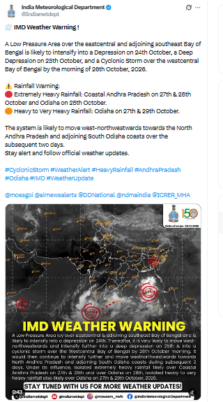
“Weather Warning!”A Low Pressure Area over the east-central and adjoining southeast Bay of Bengal is likely to intensify into a Depression on 24th October, a Deep Depression on 25th October, and a Cyclonic Storm over the west-central Bay of Bengal by the morning of 26th October, 2026,” IMD wrote.
Forecasting the path of the system, weather officials noted that the disturbance will track west-northwestwards, placing parts of Andhra Pradesh and Odisha directly in line for intense downpours and adverse meteorological conditions.
“Rainfall Warning: Extremely Heavy Rainfall: Coastal Andhra Pradesh on 27th & 28th October and Odisha on 28th October. Heavy to Very Heavy Rainfall: Odisha on 27th & 29th October. The system is likely to move west-northwestwards towards North Andhra Pradesh and adjoining South Odisha coasts over the subsequent two days. Stay alert and follow official weather updates,” IMD stated. (ANI)
Related reading