

Bhubaneswar (Odisha) [India], October 28 (ANI): Very severe cyclonic storm Arnab completed its landfall along the Andhra Pradesh and Yanam coasts between Bapatla and Visakhapatnam, southwest of Yanam, by 8 am on Wednesday, with maximum sustained wind speeds of 125–135 kmph and gusts up to 150 kmph, the India Meteorological Department (IMD) said.
In a post on X, the IMD said the cyclone crossed the coast between 2 am and 8 am on October 28, with its centre moving completely over land by 8 am.
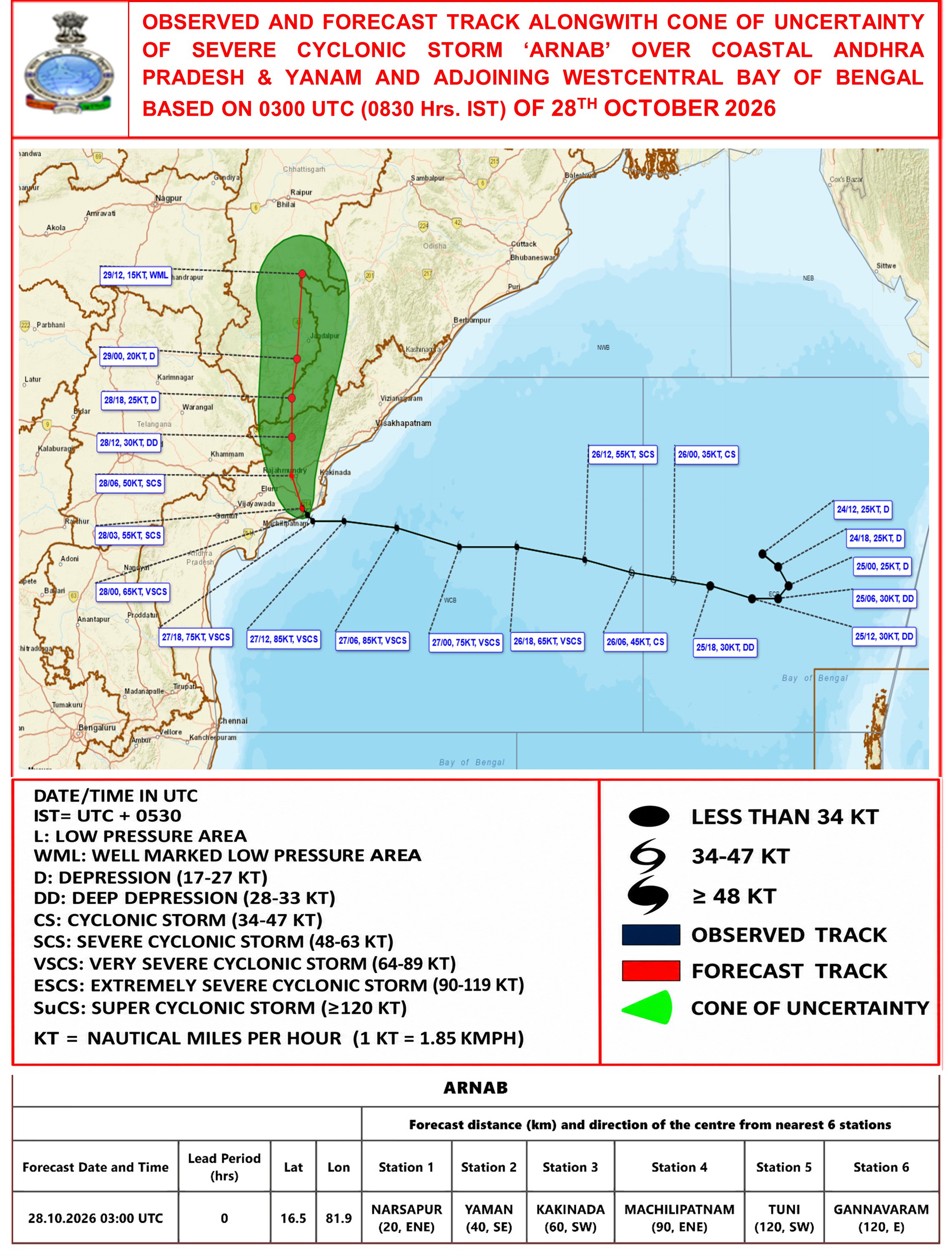
“The very severe cyclonic storm ‘Arnab’ over Westcentral Bay of Bengal off Andhra Pradesh coast moved slowly northwestwards, crossed Andhra Pradesh & Yanam coasts between Bapatla and Visakhapatnam to the Southwest of Yanam near latitude 16.450N and 81.90E, about 20 km east-northeast of Narsapur, 40 km southwest of Yanam and 60 km southwest of Kakinada during 0200 – 0800 hours IST of today, the 28th October, 2026 as a very severe cyclonic storm with the maximum sustained wind speed of 125-135 kmph gusting to 150 kmph. Latest observations indicate that the landfall process was completed, with the central region moving completely into land by 0800 hrs IST,” the IMD said.
The weather agency said the system was centred over coastal Andhra Pradesh, Yanam and the adjoining west-central Bay of Bengal at 8:30 am, around 20 km east-northeast of Narsapur, 40 km southwest of Yanam, 60 km southwest of Kakinada, 90 km east-northeast of Machilipatnam, 120 km east of Gannavaram and 120 km southwest of Tuni.
“Continuing to move further northwestwards, it lay centered at 0830 hrs IST of today, the 28th October, 2026 over Coastal Andhra Pradesh & Yanam and adjoining Westcentral Bay of Bengal, near latitude 16.5°N and longitude 81.9°E, about 20 km east-nortrheast of Narsapur (Andhra Pradesh), 40 km southwest of Yanam (Puducherry UT), 60 km southwest of Kakinada (Andhra Pradesh), 90 km east-northeast of Machilipatnam (Andhra Pradesh), 120 km east of Gannavaram (Andhra Pradesh) and 120 km southwest of Tuni,” IMD tweeted.
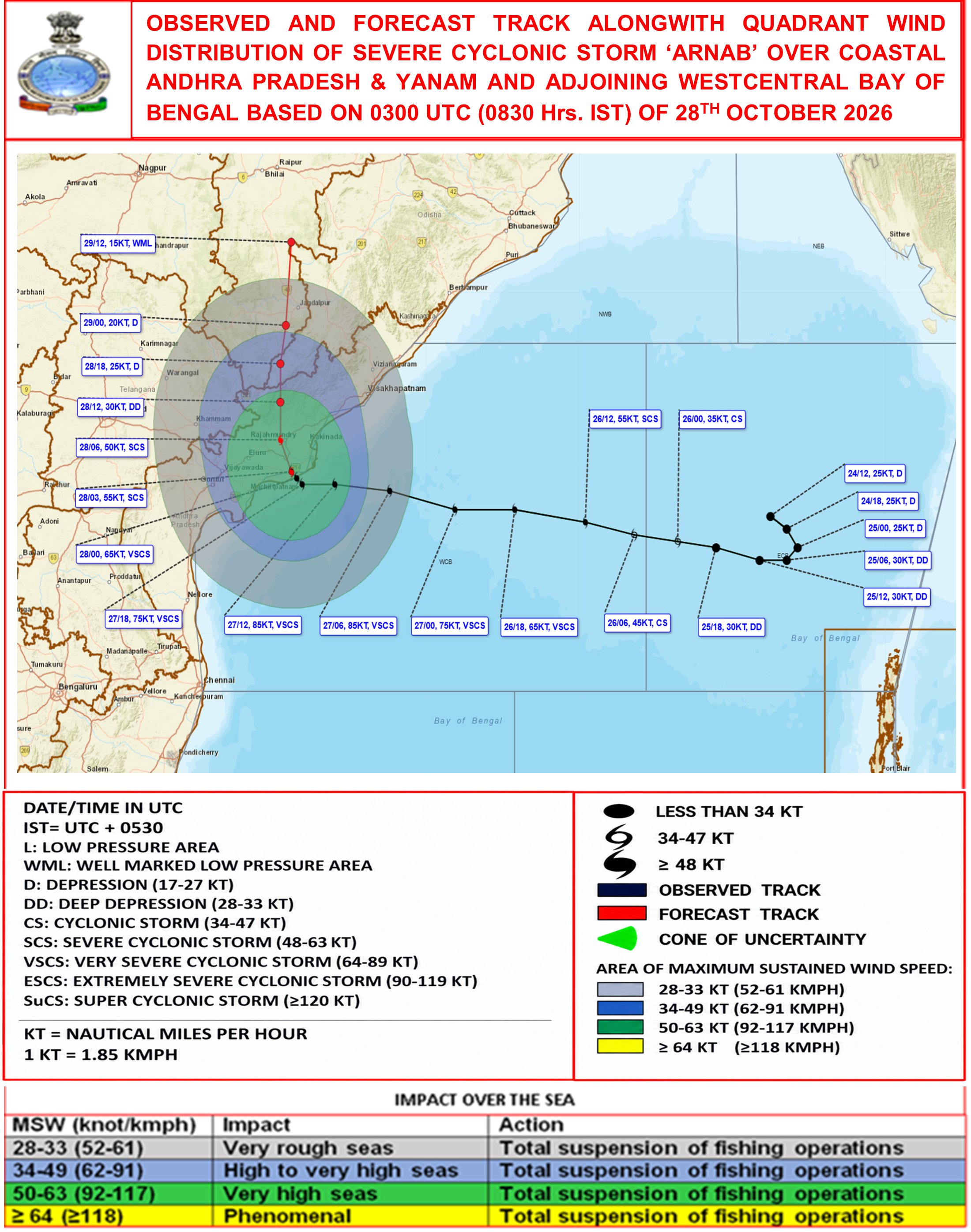
The IMD said the cyclone was projected to move north-northwestwards over the next 48 hours and gradually weaken.
“It is very likely to move north-northwestwards during next 48 hours and weaken gradually. It will weaken into a Cyclonic Storm during next 06 hours and further into a Deep Depression during subsequent 06 hours,” IMD wroye.
Meanwhile, IMD Bhubaneswar Director Manorama Mohanty said the cyclone had crossed the coast and was completely over land. She warned that rainfall and wind speeds were projected to increase in Odisha, particularly in the southern parts of the state.
“The cyclone has crossed the coast and is completely over land… Rainfall is very likely to increase, and wind speed is very likely to increase over the state of Odisha, especially over South Odisha, and in the last 24 hours there was widespread rainfall activity in some places,” Mohanty said.
She said a red warning had been issued for six districts of Odisha, with wind speeds of 60–70 kmph, gusting to 80–85 kmph, also forecast in a few districts.
“Forecast for the district of Odisha: a red warning is issued for Ganjam, Gajapati, Rayagada, Koraput, Malkangiri, and Nabarangpur districts, where heavy to very heavy rainfall is very likely to occur at a few places, with isolated extremely heavy rainfall, and wind speed is also very likely to be 60 to 70 kmph, gusting to 80 or 85 kmph in a few districts,” she said.
Mohanty added, “Even some coastal districts of North Odisha are also likely to receive heavy to very heavy rainfall. Fishermen are advised not to venture into the sea up to 29th of October,” she said. (ANI)
Related reading